Introduction
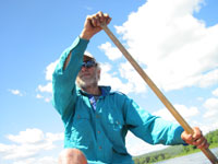
On 15th June 2013 I successfully completed a solo through-paddle of the Northern Forest Canoe Trail in my 14' solo Sylva cedar-strip
canoe by Otter Creek Smallcraft (my own business). The canoe performed admirably in diverse water conditions, sustaining scrapes and
scratches, a couple of small splits and a broken seat (my own fault). I performed nearly as admirably, and emerged weather-beaten
but not beaten by the weather, which threw at me almost everything it could think of to make life either miserable or difficult or
both.
The Trail was tough, but the weather conditions took it to a whole new dimension. This was a journey which tested my resolve, maybe
very close to the limit, but I never found out just where that limit lies, and so triumphantly paddled into Fort Kent, Maine, to be
greeted by my trusty support crew. It remains as true as ever that the harder you have to work for something, the more rewarding it
is to achieve it.
About this site
This site includes a journal of my trip, written directly from what I recorded at the time, not doctored with the benefit of
hindsight. The navigation on the right contains a link to each day's record in the journal. It also includes a little about the
history that brought me to this point. The Plan/Reality page includes some details of the planning and equipment necessary for this
undertaking, coupled with a debrief of how the planning worked out in real life on the Trail. The Stats etc. page includes a bunch
of relevant numbers (and a few irrelevant ones), as well as some 'before' and 'after' pictures.
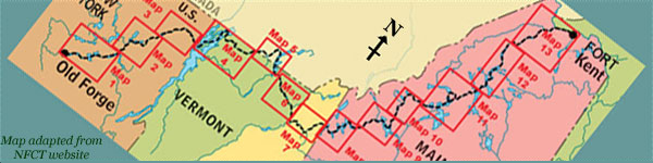
The maps show the route I took, to the best of my recollection, and distances quoted are measured along this route using Google
Earth's ruler function.
What is the Northern Forest Canoe Trail?
The NFCT is a series of traditional waterways which span the northern forests of the north-eastern USA. Long
before highways existed, these waterways were the main thoroughfares, and the canoe has long been the
primary craft of choice upon them. The trail stretches some 740 miles, crossing several different watershed
divides as it wends its way from Old Forge in the south-western Adirondacks of New York State, across the
Adirondacks, across Lake Champlain, through northern Vermont, with a loop into the province of Québec and back,
across northern New Hampshire, and way up into northern Maine, finishing at Fort Kent on the St John River. It
includes upstream and down, small and large rivers, placid and white-water, small ponds and large lakes. More
information about the trail can be found at the
NFCT's website.
Why?
A short answer might come from the lips of Sir John Hunt: "Because it's there". But there's much more to it than
that. It might be possible for me to continue to enjoy canoe-camping trips each summer, yet never see more than
a small fraction of what this trail has to offer. The only way that I shall ever know for sure which regions I
want to return to (or not) is to visit them. Couple that with the fact that very many people have been instrumental
in bringing the trail to life, and it's now more possible than ever before for this dream to come true. Then, of course,
there's the idea of the challenge, and this is a significant one: planning, logistics, equipment selection, paddling skills
in a diverse range of water conditions, camping skills, self-reliance, and so on.
Why 2013?
What better way is there to celebrate the passing of another decade of my life? True, I'm not as young as I used
to be (that's a truism if ever there was one!) but is that any reason not to seek adventure? And if not now, then when?
When?
I started on 19th May and, with the aim of finishing within a month, reached the end on 15th June. The choice of time of
year was based primarily on water levels and day-length. It is not possible to have warm water and few biting insects
(late summer) together with plenty of water in the rivers and long days (late spring). The ambitious schedule was because I
am self-employed and must still pay the bills. Taking out more than a month would have been financially interesting! It's not that
I wished to rush; in many respects it might have been more fun to linger, but that's a luxury I couldn't afford. My schedule
demanded an average of over 26 miles per day, hence the requirement for long days. Blackflies were an unpleasant inevitability!
Choice of canoe
I used a canoe of my own design and construction. Part of my living is to custom-build cedar-strip canoes, d.b.a.
Otter Creek Smallcraft. This quest involved putting both
myself and my creation to the test. A second reason to use one of my own boats was its light weight, a significant consideration
with about 55 miles of portage. I used a 14' solo asymmetric version of my Sylva design. I reinforced the keel line and added an
extra layer of fibreglass in the main strike zones (hitting rocks was inevitable over that distance!) and still it weighs only 37 lbs.
Tracking my progress
I carried a SPOT Satellite GPS Messenger, and used it to send
pre-ordained email messages to my support team, complete with latitude and longitude at the time of sending. Although
the last of these way-points has now disappeared from the website where they were displayed, I have used them to construct
the maps in my journal.
|