Introduction
In 2013 I through-paddled the Northern Forest Canoe Trail, described here. Five years later I did it again, but in the other direction (see here). It's a great trip, albeit hard work in the wrong direction. The biggest downside is the need for someone to travel very many hours to retrieve the paddler from Fort Kent (or to drop off there for the return journey). That prompted me to start looking for potential trips that are circuits, that begin and end in the same place. Now, five years after my last NFCT through-paddle, here's the first of these circuits.
It was reading Kenneth Roberts' Arundel that was the initial spark for this journey; that, and the convenience that Ray and Hildy, my always-willing support crew, live almost on the Androscoggin River in New Hampshire. My route followed the Androscoggin downstream to its end, where it meets the Kennebec at Merrymeeting Bay. Then it turned north to ascend the Kennebec. Roberts' novel relates a fictionalised but historically researched account of Benedict Arnold's march on Québec. Starting too late in the year, his army took inadequately built, leaky bateaux up the Kennebec River, carried them across to the Dead River, and proceeded up the North Branch of the Dead River to the Canadian border. There they got lost and stuck in marsh land approaching Lac Mégantic, but the survivors then ran the Chaudière River to the St Lawrence, crossed over and laid siege to Québec City, trying to storm it, unsuccessfully, on New Year's Eve 1775.
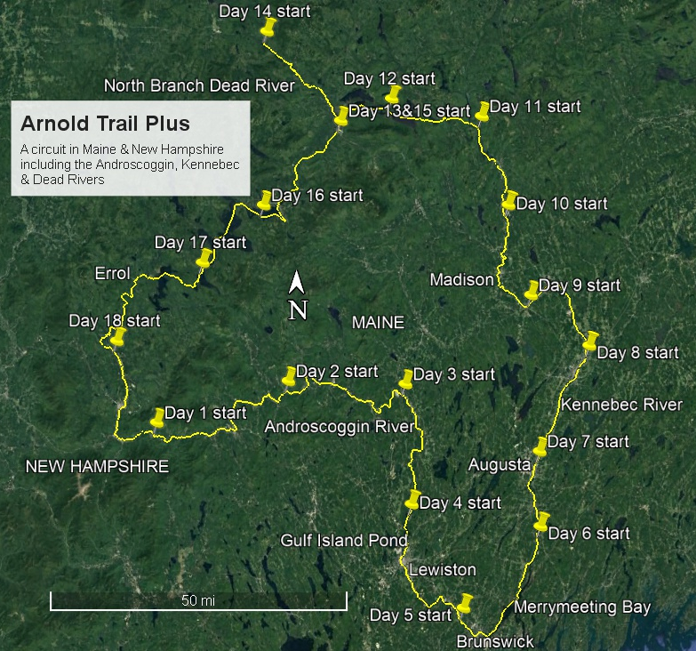
The rivers are no longer as Arnold found them. There are dams on the Kennebec where once there were falls. The Dead River is now partially impounded creating Flagstaff Lake. There are towns along the way that offer the possibility of hot meals. But my wish was to experience something of that journey ... at a better time of year, in a less leaky boat which is lighter to carry, and with no plans to lay siege to Québec City! My planned route turned back at the Canadian border and then ascended the South Branch of the Dead River (again!) to reach the Rangeley Lakes, which empty into the Androscoggin, bringing me back to my starting point at Ray & Hildy's house. See the overview map below.
About this site
This site is much like the accounts of my NFCT trips; the pages were largely cloned and then the content altered. I see no reason to add the Plan/Reality page this time. It's not that I haven't learnt anything new from my 2018 trip, but rather that those pages for the NFCT trips cover pretty much all the important stuff. The Stats etc page includes all of the numbers that might interest a reader (if you'd like to see more, please let me know what's missing), as well as some photos showing how the canoe fared and the effects of some post-trip TLC. The Journal link takes you to the day-by-day account, reproduced once more from what I recorded with pencil and paper at the end of each day, together with a selection of photos.
Choice of canoe
“The little canoe that could … and did!” and I teamed up once more. There was never any doubt. This is my 14' Sylva solo with asymmetric hull. For more information on the boat, as well as the rest of my canoe-building business, please visit Otter Creek Smallcraft.
Tracking my progress
This time I used Gaia GPS on a smartphone to upload waypoints. Those with access to my account could follow along. Of course, there were times when I had no cell signal, so uploads were spotty, waiting for when I had wi-fi or a mobile signal. But much of this trip was not remote; it passed through several sizeable towns, so the gaps were not too long.
Overview Map

|
