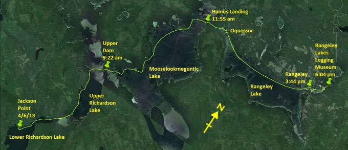
Day 17 route on Google Earth imagery
|
|
The morning is cold. I'm up soon after 5:00 am to cook breakfast, succeeding this time in keeping the wood-stove alight. The north-west
wind is bitingly cold, so I put on an extra shirt for paddling, wishing that I had not off-loaded my thermal shirt in Lancaster. Of
course the second half could not be as cold as the first – yeah, right.
As I launch I'm annoyed to slip on rocks and get my feet wet. And then, soon after pulling away, I realise that I do not have my camera.
Sure enough, back at the put-in, there it lies in a pool of water, dropped as I slipped. Just as well that it's waterproof. Finally,
with thanks to Pete, I pull away from Jackson Point.
Through the Narrows at Half Moon Cove in Upper Richardson Lake I stop to put on waterproof clothing. The cold wind is getting to me and
I have to do something to protect myself. Almost immediately the rain starts. It feels good to have been inadvertently proactive, but
I'm now on an exposed lake in cold rain and wind. There's a theme emerging for this trip. My feet, in particular, are very cold.
|
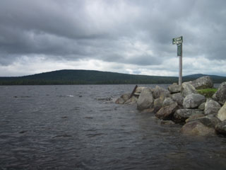
Upper Richardson Lake
|
Carry to Upper Dam
|
|
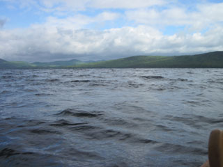
The strong wind whips up a substantial swell on Upper Richardson, not quite on the scale that we experienced last year, but sizeable
nevertheless. I lower the front of the seat, which seems to be holding together well so far – I'm tusting it more and more – and kneel
for the crossing. As I leave the lee of the western shore, the full force of the wind hits me and I have to aim well north of the carry
in order to maintain a good line across the lake. Safely arriving at the other side, I'm pleased to see that the take-out is much easier
than we found last year, and the short carry to Mooselookmeguntic Lake takes little time, not really enough to warm up the feet.
Construction is still underway at Upper Dam.
On Mooselookmeguntic I have a number of bays to cross, angling to compensate for the wind on each one. I pass Black Point, Brandy Point,
Birch Point (where we camped last summer), and then have the long, exposed crossing of Wildwood Cove to contend with. The clouds are
dark, dropping rain intermittently, and the north-west wind is, if anything, strengthening, and certainly getting no warmer. I choose a
route which curves a little into the cove, but which doesn't go as far as the islands. To do so would require heading directly into the
wind, probably a waste of effort. The crossing to Stoney Batter Point is nearly three miles of hard work, head down into the wind which
rushes past, taking body heat with it. At Stoney Batter Point I pick up a little shelter, but this is short-lived as I venture out into
the lake to cross to Haines Landing. This requires another ferry glide, aiming north of the landing to compensate for the southerly
component of my path caused by the wind which is more northerly now. The flags at Haines Landing fly perpendicular to the poles,
indicating the wind-speed.
|
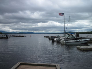
Glowering clouds on Mooselookmeguntic
|
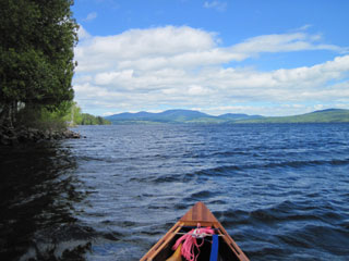
Sun and tail-wind on Rangeley Lake
|
|
More rain falls as I hike through roadworks to Oquossoc. As I pass, I hear the flag-person radio to the other end, “There's a guy with a
canoe on his head coming through”. The traffic has to wait for my steady 3 mph to clear this section of road. In Oquossoc I make one of
my better decisions: to go into the Four Seasons Cafe. MaryAnne's welcome is warm in the utmost. I order the standard hot chocolate as
well as some home-made chowder. It's good. MaryAnne makes recommendations about Bed & Breakfast accommodation in Rangeley, and even
offers, if this doesn't work out, to come and pick me up and put me up herself at no charge. I haven't met a lot of people on this trip,
but the generosity of those I have met has been astounding. For good measure she throws in a complimentary hot chocolate. Next time I'm
in Oquossoc, and who knows when that may be, I'll certainly return to the Four Seasons Cafe.
Perry, a float plane pilot, and his wife Melinda come in, celebrating their 30th wedding anniversary, the second such couple that I have
met on this trip (Trail Angels Scott and Diane were the first, rescuing my hypothermic self from beside the flooded Missisquoi back on day
7). We talk for some time and they take pictures. Melinda wants me to write a book – we'll see. It's crossed my mind, but only if I have
something worthwhile to say, more than just a sequence of places and times and gripes about the weather.
Sitting in the cafe has allowed the clouds and rain to pass. The sun is now out, but the wind is every bit as strong and cold. I
complete the carry and put in to Oquossoc Cove to paddle out on to Rangeley Lake. The strong wind propels me up the lake, and my only
effort is the occasional sprint to try to surf a wave, sometimes with success. I can't help thinking that this is a waste of a tailwind.
I don't need it today; time is plentiful. It takes me only an hour and three quarters to cover the ten miles* to Rangeley.
*In reality it's rather less than 10 miles.
|
Wind-blown in Rangeley
|
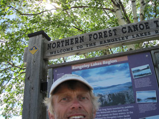
After taking the obligatory photo beside the NFCT kiosk, I head up to Rangeley Lakes Bed & Breakfast, easy to find. There's no response
to my knock on the door, but a hand-scrawled sign suggests that I should phone a certain number if I want a room. I power up my phone
again, only to confirm that I have no signal. Maybe the Tourist Information Centre can help, just across the way. No – closed on
Tuesdays. I seem to be arriving in places on all the wrong days – Enosburg Falls on a Sunday, Mansonville on a Tuesday, now Rangeley on
a Tuesday. I conclude that I'm not going to be able to stay in a B&B here. Nor do I have any means of contacting MaryAnne to return to
Oquossoc.
|
|
Besides, the weather is good, if the wind can be ignored. So I decide to find the new carry to the Rangeley Lakes Logging Museum* which
allows camping for through-paddlers. Initially I cannot find Pond Street – the sign is displayed for traffic coming from the east,
not for a pedestrian with a canoe on his head coming from the west. Eventually, however, with help from a local estate agent, I find the
access to Haley Pond and paddle to the north end, aiming deliberately to the east of where the take-out should be so that I can do a systematic
search. After investigating a couple of potential carries which clearly go nowhere, I find a short NFCT sign, hiding behind tree stumps. Here a
trail has definitely been cut, leading to the Logging Museum. I knock on the door, to no response, and then read the opening times. I'm just too
late for the 5:00 pm closure, and it's not open on Tuesdays anyway. The saga continues …
|
|
I decide to stay anyway, and unpack gear in the picnic shelter. I also locate the NFCT sign-in box and discharge that duty. Although
there are trees from which to swing, I judge that a picnic bench will make a reasonably comfortable place to put sleeping mat and bag.
It takes me a while to find the water supply – a tap on the front of the main building – and I'm glad not to have to trek back to Haley
Pond each time I want more water for food or tea. There's a plentiful supply of small wood, so I fire up the wood-stove for dinner, and
gather enough fuel for the morning too, just in case of rain.
|
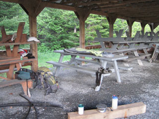
A night in the museum
|
|
I put on several layers of clothing for the night as it's clear and threatening to be cold. Tomorrow I'll aim for Stratton – MaryAnne
has recommended the White Wolf Inn – for a night of comfort before heading out into the wilds of the Spencer Stream region. Beyond that,
Jackman is probably the last opportunity to spend a night indoors.
|
|
* Renamed Maine Forestry Museum
|
|